Leg 7 Strategic Review Part 1 – Dropping like a stone
After a couple of weeks of New Zealand summer, the fleet are back in their fleeces and foulies and on their way to Brazil in what could and should be the defining leg of the race.It’s Auckland to Itajai, 7,600 nautical miles through some of the toughest waters on the planet, including a rounding of Cape Horn.
It’s a double points leg, and there’s a bonus point for the first boat to pass Cape Horn. So quite apart from being a classic route that has echoes all the way back to the race’s origins in the early 1970s, there are enough points at stake for teams to be mathematically out of contention by Brazil... scary.
The big picture
By now we should all be familiar with the idea of racing through climate zones, the notion that the earth’s oceanic climate features distinct bands, lying horizontally and looping the globe, running out from the Equator to the Poles in a mirror image.
On Leg 7 - click here for the full preview, the fleet will be racing west to east, so we are back in the same territory as Leg 3 – where we only have to worry about a couple of these climates zones. The start and finish are in regions of stable, semi-static areas of Subtropical High Pressure, while most of the leg between those points is set to the south of that in the Westerly Storm Track. This is where storms and low pressure systems swirl west-to-east around the globe, circulating the Antarctic with nothing but a handful of tiny islands to slow them down.
Keep going south
We’ve trotted out the old strategic rule for these high latitude west-to-east legs a couple of times already: keep going south till it’s blowing 40 knots, then turn left and hang on. The point being that the fastest route for this leg has always been to get south away from the influence of the high pressure and its light winds, and down into the Storm Track, where the fleet can find big breeze and bigger waves to speed them eastwards. And it’s just as true this time as it was the last time.
Opening day
Before we get into the race south though, it’s worth a look at the first 24 hours of the leg, as the fleet sailed a tactical coastal race to get around East Cape. After the opening show for the big spectator fleet in Auckland, the fleet set off upwind into a very solid easterly breeze, the first goal being the top of the Coromandel Peninsula.
After the initial flurry of tacks, the fleet settled on a long starboard and it was only after they had cleared the Coromandel that the options started to open. They arrived there in a tight group, with just over a mile between leader Dongfeng Race Team (red) and Turn the Tide on Plastic (light blue) at the back.
Offshore option
After clearing Square Top Island and the northern limit of the Coromandel, everyone tacked to port initially, and started to head south-east down the eastern side of the Peninsula.
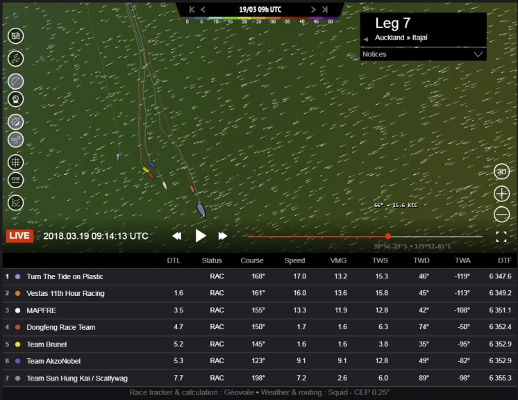
If we now snap forward to Image 1 from 09:30UTC on the 18th March, we can see the first significant split of the race.
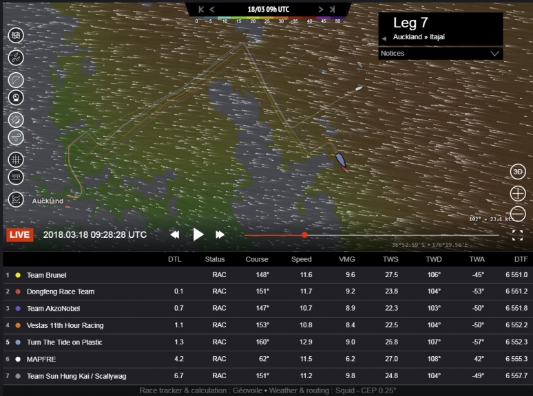
©Geovoile - Image 1 (Click for larger image)
In last place, Team Sun Hung Kai / Scallywag (grey) tacked away offshore, then sixth placed MAPFRE (white) followed them, tacking at just about the last possible moment to clear north of Great Mercury Island. The rest of the fleet were soon locked into the coast and the leverage started to open.
Spanish win
If we now go forward to Image 2 from 15:45UTC on the 18th March, the rest of the fleet have now been forced back offshore by the proximity of East Cape, and they were closing out the leverage with MAPFRE. The result was a clear if small win for the Spanish team, who now held a tiny lead of a few hundred metres from arch-rivals Dongfeng Race Team (red).
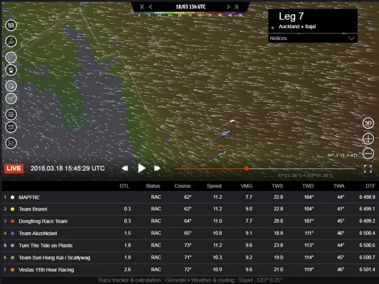
©Geovoile - Image 2 (Click for larger image)
It looks to me that this was mostly down to there being more wind offshore. The wind shift seemed to give the advantage to the inshore boats, but I think it just got a little bit lighter once they got into the lee of East Cape and that cost them.
Around East Cape
The options now closed down again, with everyone staying close to East Cape. They rounded the Cape and all tacked to port to head south together, as we see in Image 3 at 03:30UTC on the 19th March. The lighter breeze to the west of East Cape is very clear in this image. So while the right strategy was to hit the headland (as always) it was crucial not to get there too early.
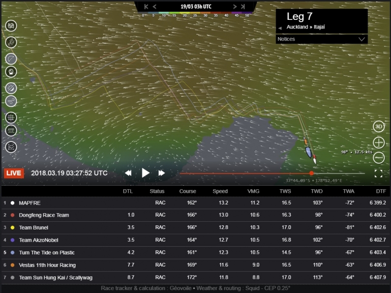
©Geovoile - Image 3 (Click for larger image)
There was also some weirdness rounding East Cape – a wind shift to the south-east which allowed them to stop the tack-fest to clear the point. And then a shift back to the east, which allowed them to tack and head south.
MAPFRE came out of all this with their lead intact, now a mile in front of Dongfeng, with the pair of them – who approached East Cape together from a bit further offshore – extending from Team Brunel (yellow), Team AkzoNobel (purple) and the rest of the pack.
Strategic view
Once the fleet had cleared East Cape the big picture strategy started to become more important, so let’s zoom out and take a look at the weather systems that were generating their easterly wind.
If we look at Image 4 from 05:00UTC on the 19th March we can see the fleet tracking along the coast at East Cape. The dominant weather feature was a big high pressure centered east of the South Island of New Zealand. The easterly wind was coming from the anti-clockwise flow around the top of the high pressure system, which was sitting almost directly across the route to Cape Horn – shown by the dashed white line.
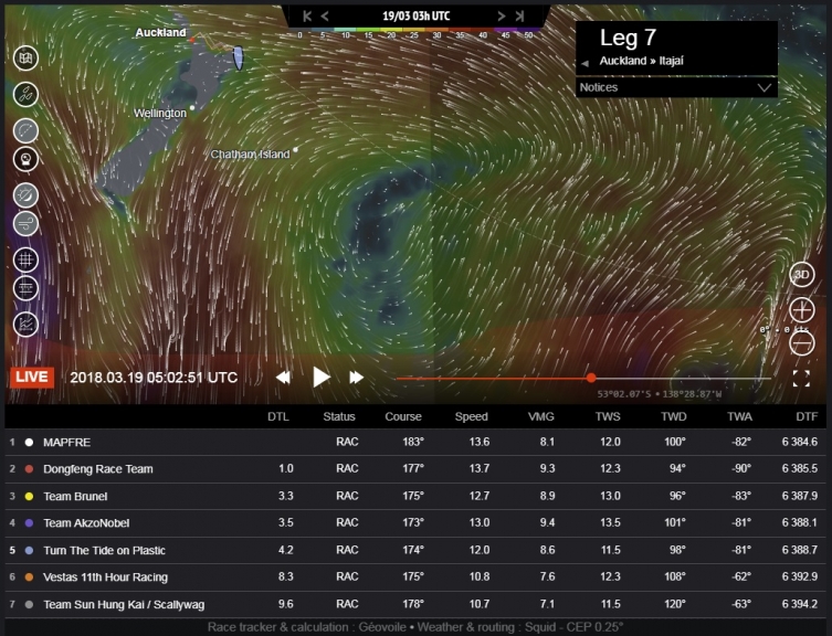
©Geovoile - Image 4 (Click for larger image)
They couldn’t go over it; the route around the top of the high meant a long slow section of upwind sailing. They couldn’t go through it; as there’s a big patch of light or zero wind in the centre. So in this case (with apologies to Bear Hunt fans) they were going to have to go under it. The route under the high meant total commitment to the dive south, and that was everyone’s plan, but the New Zealand coast wasn’t quite done with them...
Buffalo gals
I’ve been avoiding this expression – popular in my race commentaries from 1997-98 and 2008-09 – because it er... shows my age. The reference is to the line “Buffalo gal go around the outside” from the 1982 Malcolm McLaren hit, Buffalo gals (and for a little Ten Zulu nostalgia, here’s the link, but on this occasion someone else brought it up first, so that’s ok then...
Check out Image 5 from 09:15UTC on the 19th March. The leading pack of MAPFRE, Dongfeng Race Team, Team Brunel and Team AkzoNobel have hit light winds under a cloud and stopped. The boats following their line and coming up from behind – Turn the Tide on Plastic (light blue) and Vestas 11th Hour Racing (orange) – have taken a little swerve and sailed around the outside of their almost stationary opponents to steal a handy five mile lead.
©Geovoile - Image 5 (Click for larger image)
It was Simon Fisher, the navigator on Vestas 11th Hour Racing that called it; “Ourselves and TTTOP just pulled off a nice ‘buffalo girls’ move as the rest of the fleet parked in a cloud. Lucky, but well executed!" The buffalo gals live on.
Last gasp and leverage
It was a last gasp local effect, and afterwards everyone settled down to the serious business of getting south. The pack shuffled a little through the next 24 hours of racing, as the fleet started to choose their lanes.
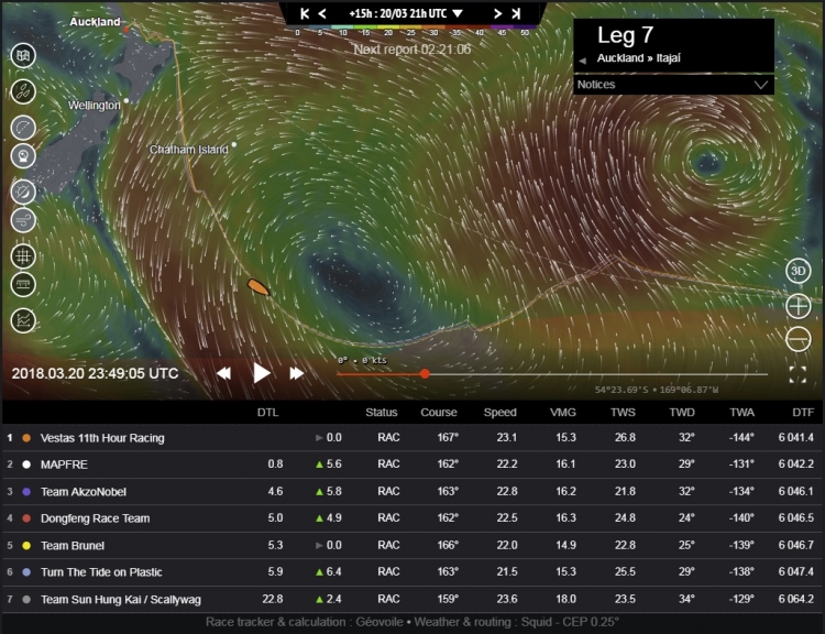
If we look at Image 6 from 07:00UTC this morning, 20th March, we can see that there is a small but potentially significant east-to-west spread across the fleet of seven miles, with Turn the Tide on Plastic out to the west with Dongfeng, and Vestas 11th Hour Racing to the east with MAPFRE.
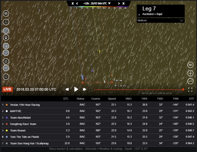
©Geovoile - Image 6 (Click for larger image)
Speed test
Before we look at the lane options, it’s worth noting that MAPFRE and Dongfeng Race Team have muscled their way back into the front row, and are now the most southerly boats. I don’t think there was anything funky here – just speed.
Check out Image 7, a plot of MAPFRE’s speed against that of Vestas 11th Hour Racing, the boat closest to them. The white line of MAPFRE is more often than not edging the orange line of Vestas 11th Hour Racing (with thanks to the Volvo Ocean Race website for adding the graphics).
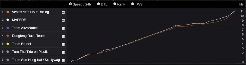
©Geovoile - Image 7 (Click for larger image)
Round the high
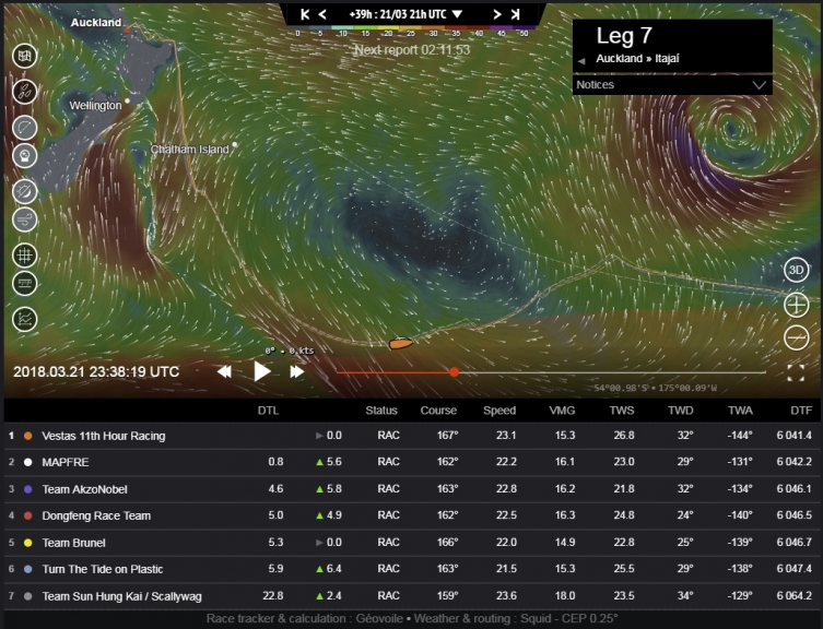
The east-to-west leverage is going to count over the next 24 hours as the fleet close with the high pressure. Let’s zoom out again and see how it could unfold. In Image 8 from 07:00UTC today, 20th March, we have the fleet in their position at that time, with their current weather, and their predicted optimal route going forward shown as dashed lines.
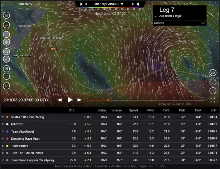
©Geovoile - Image 8 (Click for larger image)
Their dive south from East Cape is very clear, dropping like a stone towards the ice exclusion zone, marked in faint red at the bottom of the tracker image. This straight line will slowly become as curve as they shift their position relative to the centre of the high pressure, and move through the changing wind field.
Ice line and a front
The easterly wind is already a north-easterly, and it will steadily shift to a northerly direction as they continue south. They will be forced to sail VMG (velocity made good) angles to maintain their speed, and that will take them onto a south-easterly course, until they hit the ice exclusion zone.
If we go forward to midnight UTC tonight, 20th March in Image 9, we can see that they now have the northerly wind and are closing on the ice line. The next big weather feature is also visible in this image; just to the west of the fleet is a front running to the north-west from a big Southern Ocean low (centred to the south). This is where the new breeze will come from, and it’s going to push the high east, away from the fleet.
©Geovoile - Image 9 (Click for larger image)
Lane choices and pay-offs
The right choice is usually to be on whatever side of the fleet is going to get the new wind first, so my feeling is that the westerly lane ought to work. Trying to sail a shorter distance round a high than everyone else is the riskier option anyway, but it depends a lot on how close the whole fleet gets to the edge of the high. The wind doesn’t drop off linearly as you approach a high, it tends to get light quite quickly, with an almost defined boundary.
So the eastern boats need to focus on their distance from the high, and not get distracted by trying to maintain leverage to the boats to their west. Focus on the weather and not the fleet, or they could inadvertently get pushed into the light winds – the western boats are trying to go as close as they dare as well, they aren’t sailing extra distance for the fun of it.
Running with the front
If we go forward another 24 hours to Image 10 from midnight on the 21st March, we can see that the high has been pushed east, and the fleet are now running hard in the strong north-westerly wind ahead of the front. The next issue will be to manage the passage of the front, and the transition to south-westerly winds behind it.
©Geovoile - Image 10 (Click for larger image)
In Image 11 from 04:00UTC on the 23rd March we can see that this transition is predicted to happen that morning. Remember that in the north-westerly wind port gybe will be taking them along the ice boundary, while in the south-westerly wind, it’s starboard that will be the better gybe to sail along the edge of the ice zone.
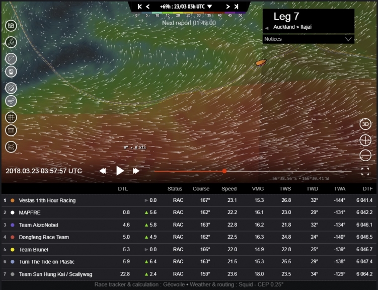
©Geovoile - Image 11 (Click for larger image)
It’s all about the timing
The navigators need to get their positioning and timing right, and not end up doing unnecessary distance on the wrong gybe in a bad shift just to avoid the ice boundary.
If we look at Image 12 from 20:00UTC on the 23rd, the predicted route has them quite a way off the ice exclusion zone to try and achieve this – it will be interesting to see if this happens in practice. There will be more wind to the south, and I have a feeling they will be gybing more often to stay close to the ice zone to stay in the breeze.
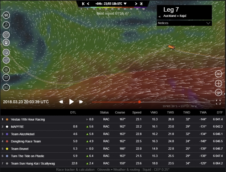
©Geovoile - Image 12 (Click for larger image)
Replay
It looks like a replay of the gybe-fest we saw in Leg 3 through the weekend – there will be more wind to the south and they will need to work hard to stay close to it. MAPFRE won this fight last time, and Dongfeng Race Team will not have forgotten it. The title is up for grabs.
The forecast for Monday has a low pressure drifting north of the ice zone and forcing the fleet to go north with it, as we see in Image 13 from 14:00UTC on the 26th March. One thing’s for sure, it’s a very active weather chart and it looks like a fast leg with plenty of breeze on the approach to Cape Horn.
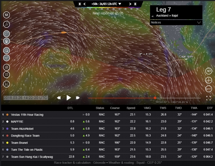
©Geovoile - Image 13 (Click for larger image)
I’ll be back after the weekend when there’s more certainty on that forecast to see how the fleet are setting up to round the greatest landmark on the circumnavigation, and score the bonus point.